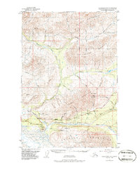
1948 Map of Anchorage D-2
USGS Topo · Published 1986About this map
Meekins Roadhouse and Sheep Mountain Lodge provide critical human anchors along the Glenn Highway in this 1948 survey of the northern Chugach range. The landscape is defined by the massive Matanuska Glacier and the Matanuska River, which carve through a valley flanked by prominent geological formations like Lion Head and the Horn Mountains. A Tractor Trail winds through the interior, suggesting the early infrastructure used for transport and resource exploration beyond the main highway. The map captures a transition from the structured surveying of the road corridor to the largely unsurveyed territory of the Chugach Mountains. Other notable landmarks include the distinctive profile of Gunsight Mountain and a Landing Strip near the river, reflecting the aviation-dependent nature of travel in the Alaska interior during the post-war era.
Find a feature on this map
41 named features on this map. Tap any name to fly to it.
Don’t see what you’re looking for? This feature index may not catch every label — zoom into the map to look around manually.
Map Details
Editions of this 1948 Anchorage D-2 Map
4 editions found
Other maps of this area

1948 · Anchorage D-3
USGS Topo · 1:63,360

1948 · Anchorage D-2
USGS Topo · 1:63,360

1948 · Anchorage D-1
USGS Topo · 1:63,360

1949 · Talkeetna Mountains A-1
USGS Topo · 1:63,360

1950 · Talkeetna Mountains
USGS Topo · 1:250,000

1951 · Anchorage
USGS Topo · 1:250,000

1951 · Anchorage D-1
USGS Topo · 1:63,360

1951 · Talkeetna Mountains A-2
USGS Topo · 1:63,360

1952 · Anchorage D-2
USGS Topo · 1:63,360

1952 · Anchorage D-3
USGS Topo · 1:63,360