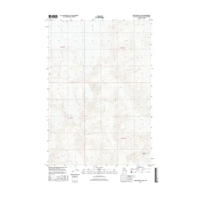
2016 Map of Anchorage D-5 NW
USGS Topo · Published 2016About this map
The Talkeetna Mountains define the high-altitude topography of this Matanuska-Susitna region, where sharp vertical relief dictates the natural drainage patterns of the upper Susitna basin. The glacial waters of the Kings River flow through the northern reaches of the quadrangle, while Granite Creek (also labeled in parts as Granite Cr) carves through the central and southern terrain. This 2016 survey illustrates a landscape largely defined by its natural hydrology and township boundaries, such as t22n r4e and t21n r3e, without the presence of permanent settlements or developed road networks. The contour density reveals the steep, unforgiving character of these peaks, offering a detailed record of the ridgelines and valley floors that have remained unchanged since mid-century mapping.
Find a feature on this map
8 named features on this map. Tap any name to fly to it.
Don’t see what you’re looking for? This feature index may not catch every label — zoom into the map to look around manually.
Map Details
Editions of this 2016 Anchorage D-5 NW Map
This is the sole edition of this map. No revisions or reprints were ever made.
Other maps of this area

1949 · Anchorage D-5
USGS Topo · 1:63,360

1949 · Talkeetna Mountains A-4
USGS Topo · 1:63,360

1950 · Talkeetna Mountains
USGS Topo · 1:250,000

1950 · Anchorage D-6
USGS Topo · 1:63,360

1951 · Anchorage
USGS Topo · 1:250,000

1952 · Anchorage D-6
USGS Topo · 1:63,360

1952 · Anchorage D-5
USGS Topo · 1:63,360
1954 · Talkeetna Mountains A-4
USGS Topo · 1:63,360

1954 · Talkeetna Mountains
USGS Topo · 1:250,000
1957 · Talkeetna Mountains
USGS Topo · 1:250,000