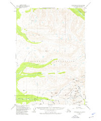
1951 Map of Anchorage D-7
USGS Topo · Published 1976About this map
Gold mining operations dominate the high elevations of the Talkeetna Mountains in this mid-century survey. The southeastern corner of the quadrangle reveals a concentrated industrial landscape centered around the Independence Mine, Gold Cord Mine, and the Martin Mine. These sites, connected by the high-altitude Hatcher Pass and the winding Willow Road, mark a period when hard-rock mining was the primary driver of activity in the district. The drainage systems of Willow Creek and Purches Creek are meticulously mapped, showing the complex network of gulches and creeks like Grubstake Gulch and Wet Gulch that were historically significant to prospectors. In the north, the terrain transitions to the broad valley of the Kashwitna River, while the Seward Meridian provides a primary surveying reference across the vast, glaciated peaks and ridges like Bald Mountain Ridge.
Find a feature on this map
53 named features on this map. Tap any name to fly to it.
Don’t see what you’re looking for? This feature index may not catch every label — zoom into the map to look around manually.
Map Details
Editions of this 1951 Anchorage D-7 Map
3 editions found

Other maps of this area

1949 · Anchorage D-7
USGS Topo · 1:63,360

1949 · Anchorage D-8
USGS Topo · 1:63,360

1950 · Talkeetna Mountains
USGS Topo · 1:250,000

1950 · Anchorage C-8
USGS Topo · 1:63,360

1950 · Anchorage D-6
USGS Topo · 1:63,360

1950 · Anchorage C-7
USGS Topo · 1:63,360

1950 · Talkeetna Mountains A-6
USGS Topo · 1:63,360

1950 · Talkeetna Mountains A-5
USGS Topo · 1:63,360

1951 · Anchorage
USGS Topo · 1:250,000

1951 · Anchorage C-6
USGS Topo · 1:63,360