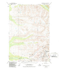
1951 Map of Anchorage D-7
USGS Topo · Published 1987About this map
The Talkeetna Mountains define this section of the Alaska Range, where the 1951 survey reveals a landscape centered on hard-rock gold mining. The concentration of mining activity is most prominent in the southeast corner, anchored by the Independence Mine State Historical Park. This district is dense with historical lodes, including the Lucky Shot Mine, Gold Bullion Mine, and the Mabel Mine, which were critical to the Willow Creek mining district's development.
Find a feature on this map
55 named features on this map. Tap any name to fly to it.
Don’t see what you’re looking for? This feature index may not catch every label — zoom into the map to look around manually.
Map Details
Editions of this 1951 Anchorage D-7 Map
3 editions found

Other maps of this area

1949 · Anchorage D-7
USGS Topo · 1:63,360

1949 · Anchorage D-8
USGS Topo · 1:63,360

1950 · Talkeetna Mountains
USGS Topo · 1:250,000

1950 · Anchorage C-8
USGS Topo · 1:63,360

1950 · Anchorage D-6
USGS Topo · 1:63,360

1950 · Anchorage C-7
USGS Topo · 1:63,360

1950 · Talkeetna Mountains A-6
USGS Topo · 1:63,360

1950 · Talkeetna Mountains A-5
USGS Topo · 1:63,360

1951 · Anchorage
USGS Topo · 1:250,000

1951 · Anchorage C-6
USGS Topo · 1:63,360