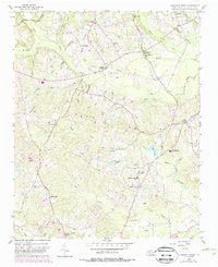
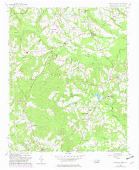
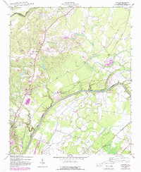
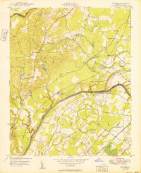
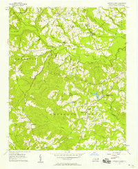
1956 Map of Anderson Creek
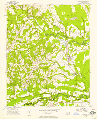
USGS Topo · Published 1988About this map
Norrington Crossroads and the surrounding agricultural lands of Harnett County define this mid-century landscape. The area is marked by a network of rural institutions, from the Anderson Creek School to numerous small houses of worship such as McRaes Chapel, Mt Olive Church, and Spring Hill Church. The topography is shaped by the Upper Little River and its various tributaries, including Barbecue Creek and Rocky Run, which drain the rolling terrain north of the Big Ridge. In the southern portion of the sheet, the landscape transitions toward the military influence of the era, shown through prominent roads like Nursery Road and Mac Arthur Road leading toward the installation boundary. Genealogists will find significant value in the well-documented burial sites such as Layton Chapel Cemetery, Rogers Cemetery, and Darroch Cemetery.
Find a feature on this map
73 named features on this map. Tap any name to fly to it.
Don’t see what you’re looking for? This feature index may not catch every label — zoom into the map to look around manually.
Map Details
Editions of this 1956 Anderson Creek Map
Other maps of this area

1948 · Fayetteville
USGS Topo · 1:62,500

1948 · Clifdale
USGS Topo · 1:62,500
1948 · Slocomb
USGS Topo · 1:24,000

1950 · Manchester
USGS Topo · 1:24,000
1950 · Slocomb
USGS Topo · 1:24,000

1951 · Clifdale
USGS Topo · 1:62,500

1953 · Raleigh
USGS Topo · 1:250,000

1954 · Raleigh
USGS Topo · 1:250,000
1956 · Anderson Creek
USGS Topo · 1:24,000
1956 · Bunnlevel
USGS Topo · 1:24,000