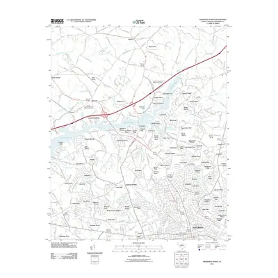
2011 Map of Anderson North
USGS Topo · Published 2011About this map
Hartwell Lake dominates the western and central portions of this landscape, its dendritic fingers reaching deep into the Piedmont terrain north of Anderson. This era reveals the dense residential expansion of suburban neighborhoods such as Northlake, Sherwood Forest, and Lexington Place, which fill the spaces between historic rural crossroads like Lebanon and North Forks. The map provides significant detail for genealogists, identifying numerous burial sites including Mountain Springs Cemetery and the Anderson First Presbyterian Cemetery. The transition from rural farmland to residential communities is evident in the naming of large tracts like Green Hill Plantation alongside modern developments. Key watercourses like Six and Twenty Creek and Millwee Creek define the natural drainage patterns that shaped early settlement long before the development of the Anderson Post Office and the surrounding urban grid.
Find a feature on this map
276 named features on this map. Tap any name to fly to it.
Don’t see what you’re looking for? This feature index may not catch every label — zoom into the map to look around manually.
Map Details
Editions of this 2011 Anderson North Map
This is the sole edition of this map. No revisions or reprints were ever made.
Other maps of this area

1888 · Pickens
USGS Topo · 1:125,000

1893 · Elberton
USGS Topo · 1:125,000

1894 · Pickens
USGS Topo · 1:125,000

1950 · La France
USGS Topo · 1:24,000

1951 · La France
USGS Topo · 1:24,000

1951 · Clemson
USGS Topo · 1:24,000

1954 · Greenville
USGS Topo · 1:250,000

1957 · Anderson
USGS Topo · 1:62,500

1958 · Greenville
USGS Topo · 1:250,000

1959 · Hartwell NE
USGS Topo · 1:24,000