
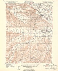
1948 Map of Anderson
USGS Topo · Published 1948About this map
Anderson and Cottonwood serve as the primary hubs along the Southern Pacific rail line in this post-war landscape. The terrain transitions from the open Stillwater Plains near the Sacramento River into a network of gulches and creeks, such as Clover Creek and Cottonwood Creek, which define the local drainage patterns and property boundaries. A rural network of family-named ranches and local schools, including Hooker Sch and Farquhar Sch, reflects a mid-century community tied closely to the land.
Find a feature on this map
47 named features on this map. Tap any name to fly to it.
Don’t see what you’re looking for? This feature index may not catch every label — zoom into the map to look around manually.
Map Details
Editions of this 1948 Anderson Map
2 editions found
Other maps of this area

1890 · Red Bluff
USGS Topo · 1:250,000

1894 · Red Bluff
USGS Topo · 1:250,000

1901 · Redding
USGS Topo · 1:125,000

1905 · Tehama
USGS Topo · 1:62,500

1913 · Weaverville
USGS Topo · 1:125,000

1932 · Olinda
USGS Topo · 1:31,680

1935 · Olinda
USGS Topo · 1:31,680

1944 · Redding
USGS Topo · 1:62,500

1944 · French Gulch
USGS Topo · 1:62,500

1944 · Tuscan Buttes
USGS Topo · 1:62,500