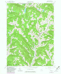
1965 Map of Andes
USGS Topo · Published 1982About this map
The Catskill Mountains landscape of central Delaware County is defined by steep ridges and winding valley bottoms, anchored by the village of Andes. Near the northern boundary, the Little Delaware River flows through a valley dotted with family-named hollows and landmarks like Lake Delaware and the Cabin Hill Ch. The land use pattern here reflects a mix of remote highland conservation and rural industry, evidenced by the Wolf Hollow Wildlife Management Area and the Murphy Hill State Forest. In the southern reaches, the Old Railroad Grade follows the Tremper Kill corridor, a relic of the timber and dairy transport networks that once linked these isolated settlements to larger markets. Dozens of named hollows, including Gladstone Hollow and Russell Hollow, trace the historic routes of upland farmers and residents.
Find a feature on this map
56 named features on this map. Tap any name to fly to it.
Don’t see what you’re looking for? This feature index may not catch every label — zoom into the map to look around manually.
Map Details
Editions of this 1965 Andes Map
3 editions found
Other maps of this area

1901 · Margaretville
USGS Topo · 1:62,500

1904 · Hobart
USGS Topo · 1:62,500

1904 · Margaretville
USGS Topo · 1:62,500

1909 · Delhi
USGS Topo · 1:62,500

1911 · Delhi
USGS Topo · 1:62,500

1922 · Andes
USGS Topo · 1:62,500

1924 · Andes
USGS Topo · 1:62,500

1943 · Delhi
USGS Topo · 1:24,000

1943 · Bloomville
USGS Topo · 1:24,000
1945 · Arena
USGS Topo · 1:24,000