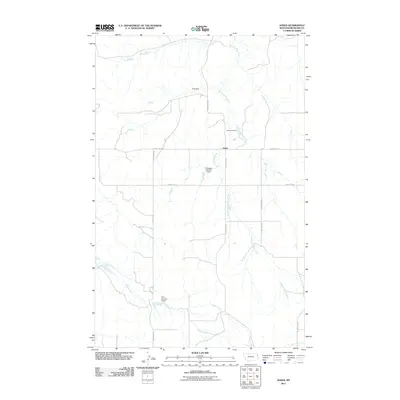
2011 Map of Andes
USGS Topo · Published 2011About this map
Andes and its surrounding Richland County landscape are defined by a network of drainage systems and small-scale water management projects typical of eastern Montana. The map illustrates a rural environment where life follows the paths of Hardscrabble Creek and Timber Creek, which cut across the terrain. Local engineering is evident in features like Frog Dam, C Stoppler Number 1 Dam, and Peer Number 2 Dam, suggesting a reliance on reservoir systems for livestock or agriculture in this semi-arid region. The presence of the Andes Cemetery north of the primary settlement provides a key point of interest for genealogists and local historians tracking family histories in the area. A grid of local infrastructure, including County RD-332 and County RD-143, connects these scattered water features and provides the framework for the community at the start of the twenty-first century.
Find a feature on this map
15 named features on this map. Tap any name to fly to it.
Don’t see what you’re looking for? This feature index may not catch every label — zoom into the map to look around manually.
Map Details
Editions of this 2011 Andes Map
This is the sole edition of this map. No revisions or reprints were ever made.
Other maps of this area

1909 · Glendive
USGS Topo · 1:250,000

1954 · Glendive
USGS Topo · 1:250,000

1954 · Wolf Point
USGS Topo · 1:250,000

1957 · Glendive
USGS Topo · 1:250,000

1958 · Wolf Point
USGS Topo · 1:250,000

1958 · Glendive
USGS Topo · 1:250,000
1969 · Twomile Creek
USGS Topo · 1:24,000

1969 · Three Buttes
USGS Topo · 1:24,000

1969 · Dugout Creek
USGS Topo · 1:24,000

1972 · Girard
USGS Topo · 1:24,000