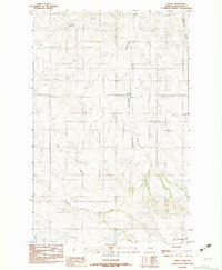
1983 Map of Andes
USGS Topo · Published 1983About this map
Andes serves as the central point of reference in this landscape of the Missouri River basin, where a series of seasonal drainages have carved the terrain. The hydrological network is the primary defining characteristic of the area, featuring Hardscrabble Creek and its tributary, East Hardscrabble Creek, which drain toward the south and east. Other major geographic markers include Garden Coulee in the north and Timber Creek and Charlie Creek along the southern edges. Evidence of local industry and infrastructure is present through the marking of a Gravel Pit and Gravel Pits, likely tied to the maintenance of the county road system that connects the remote homesteads of Richland County. The map provides a clear look at the township and range divisions, such as the boundary between T 26 N and T 25 N, which dictated the early settlement patterns and property lines of this Montana ranching country.
Find a feature on this map
11 named features on this map. Tap any name to fly to it.
Don’t see what you’re looking for? This feature index may not catch every label — zoom into the map to look around manually.
Map Details
Editions of this 1983 Andes Map
This is the sole edition of this map. No revisions or reprints were ever made.
Other maps of this area

1909 · Glendive
USGS Topo · 1:250,000

1954 · Glendive
USGS Topo · 1:250,000

1954 · Wolf Point
USGS Topo · 1:250,000

1957 · Glendive
USGS Topo · 1:250,000

1958 · Wolf Point
USGS Topo · 1:250,000

1958 · Glendive
USGS Topo · 1:250,000
1969 · Twomile Creek
USGS Topo · 1:24,000

1969 · Three Buttes
USGS Topo · 1:24,000

1969 · Dugout Creek
USGS Topo · 1:24,000

1972 · Girard
USGS Topo · 1:24,000