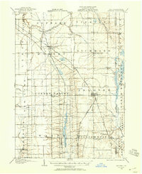
1905 Map of Andover
USGS Topo · Published 1958About this map
Andover and its neighboring townships in Ashtabula County are defined by a complex network of rail lines and drainage basins at the turn of the century. The map illustrates a landscape of established small settlements and rural crossroads, where the Lake Shore and Michigan Southern R.R. and the Pennsylvania R.R. intersect, creating vital transport hubs at Dorset and Andover. This era of the Eastern Ohio borderlands shows a transition toward organized rail freight, evidenced by the Pennsylvania R.R. (Low Grade Cutoff) running north-south through Cherry Valley. Away from the tracks, the terrain is marked by family-centric locales and community centers such as South Denmark Church, Steamburg Church, and the Williamsfield P.O.. The eastern edge of the survey follows the winding Shenango River along the state line, where landmarks like Manning Bridge and Hemlock Island stand before the massive reservoir projects of later decades.
Find a feature on this map
63 named features on this map. Tap any name to fly to it.
Don’t see what you’re looking for? This feature index may not catch every label — zoom into the map to look around manually.
Map Details
Editions of this 1905 Andover Map
3 editions found
Other maps of this area

1900 · Girard
USGS Topo · 1:62,500

1905 · Andover
USGS Topo · 1:48,000

1905 · Ashtabula
USGS Topo · 1:62,500

1905 · Bristolville
USGS Topo · 1:62,500

1905 · Jefferson
USGS Topo · 1:62,500

1906 · Conneaut
USGS Topo · 1:62,500

1906 · Linesville
USGS Topo · 1:62,500

1907 · Andover
USGS Topo · 1:62,500

1907 · Kinsman
USGS Topo · 1:62,500

1907 · Bristolville
USGS Topo · 1:62,500