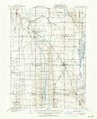
1905 Map of Andover
USGS Topo · Published 1964About this map
Andover serves as a primary hub for this early twentieth-century landscape, situated where several local roads and rail lines converge near the Ohio Pennsylvania Boundary Line. The region's economy and settlement patterns are clearly defined by the Lake Shore and Michigan Southern RR and the Pennsylvania RR, which connect rural outposts like Dorset, Leon, and Simons. Rural life is anchored by small community centers and religious sites, such as the South Denmark Church and Steamburg Church, while the physical geography is dominated by the meandering paths of the Ashtabula River and Pymatuning Creek.
Find a feature on this map
51 named features on this map. Tap any name to fly to it.
Don’t see what you’re looking for? This feature index may not catch every label — zoom into the map to look around manually.
Map Details
Editions of this 1905 Andover Map
3 editions found
Other maps of this area

1900 · Girard
USGS Topo · 1:62,500

1905 · Andover
USGS Topo · 1:48,000

1905 · Ashtabula
USGS Topo · 1:62,500

1905 · Bristolville
USGS Topo · 1:62,500

1905 · Jefferson
USGS Topo · 1:62,500

1906 · Conneaut
USGS Topo · 1:62,500

1906 · Linesville
USGS Topo · 1:62,500

1907 · Andover
USGS Topo · 1:62,500

1907 · Kinsman
USGS Topo · 1:62,500

1907 · Bristolville
USGS Topo · 1:62,500