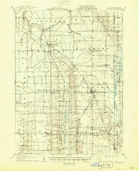
1907 Map of Andover
USGS Topo · Published 1946About this map
The town of Andover serves as a central hub on this eastern Ohio landscape, where the Lake Shore and Michigan Southern RR and the Jefferson Branch converge. The terrain is defined by the headwaters of the Ashtabula River and the meandering course of Pymatuning Creek, which flows south toward Williamsfield. This era reveals a network of small agricultural settlements and religious centers such as Richmond Center, Cherry Valley, and the Steamburg Church, many of which were linked by historical thoroughfares like the Old Turnpike Road. Across the Ohio Pennsylvania Boundary Line, the map captures the transition into Crawford County, Pennsylvania, showing the early infrastructure of Hemlock Island and Manning Bridge before the landscape was altered by later water management projects. Genealogists will find interest in the precise locations of the South Denmark Church and the original Williamsfield P O.
Find a feature on this map
58 named features on this map. Tap any name to fly to it.
Don’t see what you’re looking for? This feature index may not catch every label — zoom into the map to look around manually.
Map Details
Editions of this 1907 Andover Map
4 editions found
Other maps of this area

1900 · Girard
USGS Topo · 1:62,500

1905 · Andover
USGS Topo · 1:48,000

1905 · Ashtabula
USGS Topo · 1:62,500

1905 · Bristolville
USGS Topo · 1:62,500

1905 · Jefferson
USGS Topo · 1:62,500

1906 · Conneaut
USGS Topo · 1:62,500

1906 · Linesville
USGS Topo · 1:62,500

1907 · Andover
USGS Topo · 1:62,500

1907 · Kinsman
USGS Topo · 1:62,500

1907 · Bristolville
USGS Topo · 1:62,500