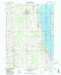
1994 Map of Andover
USGS Topo · Published 1997About this map
The Pymatuning Reservoir dominates the eastern landscape of this Ashtabula County borderland, where the waters of the Shenango River meet the Ohio Pennsylvania state line. The village of Andover serves as the central hub, situated near the headwaters of Black Creek. Cultural landmarks reflect a mid-century community character, including a Drive-in Theater south of town and the recreational shoreline of Pymatuning State Park.
Find a feature on this map
47 named features on this map. Tap any name to fly to it.
Don’t see what you’re looking for? This feature index may not catch every label — zoom into the map to look around manually.
Map Details
Editions of this 1994 Andover Map
This is the sole edition of this map. No revisions or reprints were ever made.
Other maps of this area

1905 · Andover
USGS Topo · 1:48,000

1906 · Linesville
USGS Topo · 1:62,500

1907 · Andover
USGS Topo · 1:62,500

1907 · Kinsman
USGS Topo · 1:62,500

1908 · Shenango
USGS Topo · 1:62,500

1908 · Linesville
USGS Topo · 1:62,500

1950 · Cleveland
USGS Topo · 1:250,000

1956 · Cleveland
USGS Topo · 1:250,000

1958 · Greensville West
USGS Topo · 1:24,000

1959 · Hartstown
USGS Topo · 1:24,000