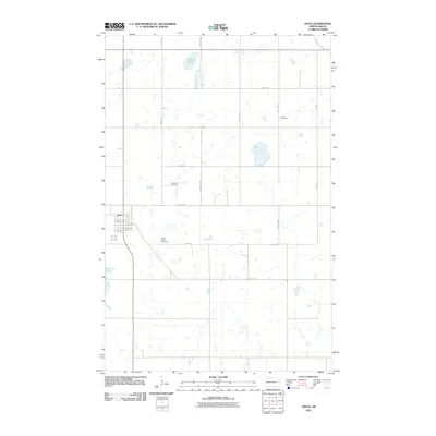
2011 Map of Aneta
USGS Topo · Published 2011About this map
Aneta anchors the western edge of this prairie landscape, where the town's residential grid is defined by streets like Moon Ave and Stearns Ave. The surrounding countryside reveals a high density of rural burial grounds, including Silent Hill Cemetery, Sacred Heart Cemetery, and Holen Cemetery, each offering vital clues for genealogists and local historians tracing family roots in Nelson County. The terrain is characterized by the post-glacial hydrology of the Northern Plains, dominated by the large basin of Matson Slough and the waters of Pickeral Lake. A strict section-line road network, featuring routes such as 125th Ave NE and County Hwy 7, cuts across the landscape, connecting the town to the sprawling agricultural fields and minor drainages like Beaver Creek in the northeast corner.
Find a feature on this map
22 named features on this map. Tap any name to fly to it.
Don’t see what you’re looking for? This feature index may not catch every label — zoom into the map to look around manually.
Map Details
Editions of this 2011 Aneta Map
This is the sole edition of this map. No revisions or reprints were ever made.
Other maps of this area

1939 · Niagara
USGS Topo · 1:62,500

1942 · McVille
USGS Topo · 1:62,500

1952 · Grand Forks
USGS Topo · 1:250,000

1952 · New Rockford
USGS Topo · 1:250,000

1956 · New Rockford
USGS Topo · 1:250,000

1956 · Grand Forks
USGS Topo · 1:250,000

1963 · Niagara SW
USGS Topo · 1:24,000
1963 · McVille SE
USGS Topo · 1:24,000

1963 · Logan Center
USGS Topo · 1:24,000

1966 · Grand Forks
USGS Topo · 1:250,000