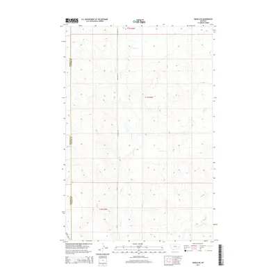
2014 Map of Angela NE
USGS Topo · Published 2014About this map
The rolling plains of eastern Montana define this landscape where the Rosebud County and Custer County line runs along the western edge. Sparse infrastructure and deep seasonal drainages characterize the terrain, with Crow Rock Rd and Cr-109 providing the primary north-south passage through the area. Natural watercourses like Grimes Cr, Horse Cr, and Alkali Cr carve the high prairie, illustrating the drainage patterns vital to ranching operations in this part of the state. The map details the Public Land Survey System township boundaries, including t11n r45e, which organize the expansive sections of this remote cattle country near the highway corridor of Mt-59.
Find a feature on this map
10 named features on this map. Tap any name to fly to it.
Don’t see what you’re looking for? This feature index may not catch every label — zoom into the map to look around manually.
Map Details
Editions of this 2014 Angela NE Map
This is the sole edition of this map. No revisions or reprints were ever made.
Other maps of this area

1953 · Miles City
USGS Topo · 1:250,000

1954 · Forsyth
USGS Topo · 1:250,000

1957 · Miles City
USGS Topo · 1:250,000

1957 · Forsyth
USGS Topo · 1:250,000

1958 · Miles City
USGS Topo · 1:250,000

1958 · Forsyth
USGS Topo · 1:250,000

1965 · Rock Springs School
USGS Topo · 1:24,000

1965 · Twin Buttes School
USGS Topo · 1:24,000
1965 · Crow Rock SE
USGS Topo · 1:24,000

1969 · Horse Creek Hill
USGS Topo · 1:24,000