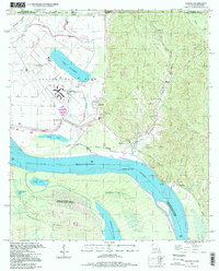
1996 Map of Angola
USGS Topo · Published 1998About this map
The Louisiana State Penitentiary and State Penal Farm dominate this riverbend landscape, organized around an extensive network of levees and specialized facilities. The terrain is defined by the shifting course of the Mississippi River, which separates Raccourci Island from the mainland and leaves behind oxbow features like Killarney Lake and the Raccourci Old River. To the east, the topography rises sharply into the hills near Tunica, where a cluster of community landmarks such as Tunica School, Tunica Hills Church, and Comely Cemetery suggest the local social fabric outside the prison grounds. Along the riverbank, Como Landing and Leatherman Point mark historical transit spots, while an Old Railroad Grade traces a path through the lowlands, reflecting the era's reliance on both rail and water for moving goods through West Feliciana Parish.
Find a feature on this map
47 named features on this map. Tap any name to fly to it.
Don’t see what you’re looking for? This feature index may not catch every label — zoom into the map to look around manually.
Map Details
Editions of this 1996 Angola Map
This is the sole edition of this map. No revisions or reprints were ever made.
Other maps of this area

1906 · Bayou Sara
USGS Topo · 1:125,000

1936 · Woodville
USGS Topo · 1:62,500

1939 · St. Francisville
USGS Topo · 1:62,500

1939 · Artonish
USGS Topo · 1:62,500

1941 · Batchelor
USGS Topo · 1:62,500

1953 · Natchez
USGS Topo · 1:250,000

1954 · Artonish
USGS Topo · 1:62,500

1954 · Baton Rouge
USGS Topo · 1:250,000

1955 · Artonish
USGS Topo · 1:62,500

1955 · Batchelor
USGS Topo · 1:62,500