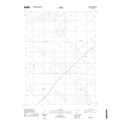
2017 Map of Angora NE
USGS Topo · Published 2017About this map
Hay Valley occupies the southwestern portion of this Nebraska landscape, characterized by the wide drainage patterns and intermittent wetlands of Morrill County. The settlement of Bonner is the primary focal point of human activity, situated near the intersection of several rural transportation routes. Local navigation in this region relies on a network of named roads including Daharsh, Rd 128, and N Co Rd, which delineate the expansive sections of the Public Land Survey System. The map's detail reveals the high-plains topography, where subtle elevation changes and depressions create numerous small seasonal water bodies across the terrain. This 2017 edition provides a clear record of the intersection between established ranching land and the remote infrastructure typical of the Nebraska Panhandle.
Find a feature on this map
9 named features on this map. Tap any name to fly to it.
Don’t see what you’re looking for? This feature index may not catch every label — zoom into the map to look around manually.
Map Details
Editions of this 2017 Angora NE Map
This is the sole edition of this map. No revisions or reprints were ever made.
Other maps of this area

1896 · Browns Creek
USGS Topo · 1:125,000

1898 · Camp Clarke
USGS Topo · 1:125,000

1899 · Browns Creek
USGS Topo · 1:125,000

1947 · Bronco Lake
USGS Topo · 1:24,000

1948 · Hemingford 4 SW
USGS Topo · 1:24,000

1948 · Hemingford 4 SE
USGS Topo · 1:24,000

1949 · Lynn
USGS Topo · 1:62,500
1949 · Bronco Lake
USGS Topo · 1:24,000

1954 · Scottsbluff
USGS Topo · 1:250,000

1955 · Alliance
USGS Topo · 1:250,000