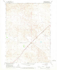
1965 Map of Angora NE
USGS Topo · Published 1967About this map
Chicago Burlington and Quincy tracks cut a diagonal path across this High Plains landscape, connecting the small settlement of Bonner to the wider Nebraska rail network. The terrain is defined by the broad depressions of Hay Valley and Haynes, reflecting the characteristic topography of Morrill County during the mid-1960s. This survey, completed as part of the Missouri River Basin development program, captures the rural infrastructure of the era, including the Hall Landing Strip and a Roadside Park along the highway. Fine red dashed lines throughout the sheet provide a rare grounded look at local land management, indicating selected fence and field lines visible from aerial photography. These details offer a precise view of how the land was partitioned and utilized for ranching or agriculture before more modern industrial pivots changed the local footprint.
Find a feature on this map
8 named features on this map. Tap any name to fly to it.
Don’t see what you’re looking for? This feature index may not catch every label — zoom into the map to look around manually.
Map Details
Editions of this 1965 Angora NE Map
This is the sole edition of this map. No revisions or reprints were ever made.
Other maps of this area

1896 · Browns Creek
USGS Topo · 1:125,000

1898 · Camp Clarke
USGS Topo · 1:125,000

1899 · Browns Creek
USGS Topo · 1:125,000

1947 · Bronco Lake
USGS Topo · 1:24,000

1948 · Hemingford 4 SW
USGS Topo · 1:24,000

1948 · Hemingford 4 SE
USGS Topo · 1:24,000

1949 · Lynn
USGS Topo · 1:62,500
1949 · Bronco Lake
USGS Topo · 1:24,000

1954 · Scottsbluff
USGS Topo · 1:250,000

1955 · Alliance
USGS Topo · 1:250,000