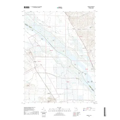
2017 Map of Annada
USGS Topo · Published 2017About this map
Annada sits at the base of Saltpeter Bluff in this riverfront landscape along the border of Missouri and Illinois. The terrain is defined by the shifting course of the Mississippi River, which separates Pike County, Missouri, from Calhoun County, Illinois. The river is choked with numerous named landforms including Eagle Island, Amaranth Island, and the ominously named Dead Mans Island. To the west, the landscape rises into the Cooper Knobs and Kissenger Hill, while the lowlands are dominated by a complex network of backwaters like Negro Slough and Rahburn Slough. This survey captures the rural character of settlements such as Kissenger and Belleview, highlighting the proximity of historical burial sites like Long Cem and Poor Cem. The local transportation network consists primarily of county routes like Pike 214 and riverfront paths such as Mississippi River Rd, serving a region deeply tied to the river's hydrology.
Find a feature on this map
75 named features on this map. Tap any name to fly to it.
Don’t see what you’re looking for? This feature index may not catch every label — zoom into the map to look around manually.
Map Details
Editions of this 2017 Annada Map
This is the sole edition of this map. No revisions or reprints were ever made.
Other maps of this area

1930 · Pearl
USGS Topo · 1:62,500

1930 · Nebo
USGS Topo · 1:62,500

1930 · Hardin
USGS Topo · 1:62,500

1934 · Nebo
USGS Topo · 1:48,000

1934 · Elsberry
USGS Topo · 1:48,000

1934 · Hardin
USGS Topo · 1:62,500

1938 · Hardin
USGS Topo · 1:62,500

1942 · Nebo
USGS Topo · 1:62,500

1942 · Elsberry
USGS Topo · 1:62,500

1948 · Quincy
USGS Topo · 1:250,000