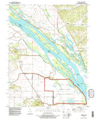
1993 Map of Annada
USGS Topo · Published 1996About this map
The Mississippi River forms a sprawling aquatic boundary between Illinois and Missouri on this 1993 revision, shaping a landscape defined by complex side channels, islands, and flood mitigation efforts. Near Annada, the river environment is characterized by wide sloughs and chutes, including Slim Chute and The Sny, which navigate around significant landmasses like Carroll Island and Clarksville Island. The map documents the extensive Levee systems protecting agricultural lands and small settlements such as Kissenger and Belleview.
Find a feature on this map
50 named features on this map. Tap any name to fly to it.
Don’t see what you’re looking for? This feature index may not catch every label — zoom into the map to look around manually.
Map Details
Editions of this 1993 Annada Map
This is the sole edition of this map. No revisions or reprints were ever made.
Other maps of this area

1930 · Pearl
USGS Topo · 1:62,500

1930 · Nebo
USGS Topo · 1:62,500

1930 · Hardin
USGS Topo · 1:62,500

1934 · Nebo
USGS Topo · 1:48,000

1934 · Elsberry
USGS Topo · 1:48,000

1934 · Hardin
USGS Topo · 1:62,500

1938 · Hardin
USGS Topo · 1:62,500

1942 · Nebo
USGS Topo · 1:62,500

1942 · Elsberry
USGS Topo · 1:62,500

1948 · Quincy
USGS Topo · 1:250,000