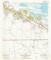
1969 Map of Annaville
USGS Topo · Published 1977About this map
The Nueces River delta and the industrial expansion of northwest Corpus Christi define this 1969 landscape, where shipping and petroleum infrastructure meet growing residential neighborhoods. Rapid development is evident in Annaville and Arlington Heights, bolstered by the Stonewall Mall Shopping Center and the Tuloso-Midway High Sch. To the south, the Saxet Oil Field is a grid of extraction, while the industrial corridor along the Viola Channel and Viola Turning Basin shows the scale of the local Refinery operations.
Find a feature on this map
43 named features on this map. Tap any name to fly to it.
Don’t see what you’re looking for? This feature index may not catch every label — zoom into the map to look around manually.
Map Details
Editions of this 1969 Annaville Map
3 editions found
Other maps of this area

1924 · Petronilla
USGS Topo · 1:62,500

1925 · Robstown
USGS Topo · 1:62,500

1925 · Oso Creek
USGS Topo · 1:62,500

1925 · Corpus Christi
USGS Topo · 1:62,500

1950 · Corpus Christi
USGS Topo · 1:250,000

1951 · Corpus Christi
USGS Topo · 1:24,000

1951 · Corpus Christi
USGS Topo · 1:62,500

1951 · Oso Creek NW
USGS Topo · 1:24,000

1951 · Oso Creek
USGS Topo · 1:62,500

1954 · Robstown
USGS Topo · 1:62,500
Featured Places
- Corpus Christi, TX
- Violet, TX
- Clarkwood, Corpus Christi
- McNorton, Corpus Christi
- San Juan, Corpus Christi