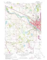
1967 Map of Anoka
USGS Topo · Published 1980About this map
The Mississippi River and Rum River define the industrial and civic core of Anoka during this era of late twentieth-century expansion. The landscape is a complex mix of riverine islands like Cloquet Island and Kings Island alongside established institutions such as the State Hospital and various civic centers. The presence of the Burlington Northern railroad and the Gateway North Industrial Airport highlights the region's importance as a transportation and logistics hub. To the south and west, the suburban growth of Champlin, Maple Grove, and Brooklyn Park begins to surround older landmarks, including several historic burial grounds like Calvary and Forest Hill. Preservation efforts are visible at the Schmidt State Wildlife Management Areas, while numerous schools such as St Stephens and Madison Junior High serve the growing residential population.
Find a feature on this map
62 named features on this map. Tap any name to fly to it.
Don’t see what you’re looking for? This feature index may not catch every label — zoom into the map to look around manually.
Map Details
Editions of this 1967 Anoka Map
4 editions found
Other maps of this area

1902 · Anoka
USGS Topo · 1:62,500

1909 · Rockford
USGS Topo · 1:62,500

1916 · St. Francis
USGS Topo · 1:62,500

1919 · St. Francis
USGS Topo · 1:62,500

1952 · Minneapolis North
USGS Topo · 1:24,000

1953 · Stillwater
USGS Topo · 1:250,000

1955 · Osseo
USGS Topo · 1:24,000

1955 · Anoka
USGS Topo · 1:24,000

1955 · Coon Rapids
USGS Topo · 1:24,000

1955 · Anoka
USGS Topo · 1:62,500