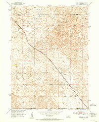
1951 Map of Anselmo NW
USGS Topo · Published 1953About this map
The Chicago Burlington and Quincy railroad cuts a sharp diagonal through this remote Nebraska landscape, anchoring the transit corridor between the Dunning and Edith regions. Surveyed in the early 1950s, the terrain is defined by undulating sand hills and the intermittent drainage of Rifle Creek. The map documents a sparse but organized rural infrastructure, where life centered around small educational outposts such as Hoosier Valley Sch in the Hayes area and Grand View Sch further south. These schools served a ranching community that relied on scattered Windmill sites for water in an arid environment. The boundary between Blaine Co and Custer Co is clearly delineated, showing how political lines bisect the rolling topography of the Victoria district.
Find a feature on this map
10 named features on this map. Tap any name to fly to it.
Don’t see what you’re looking for? This feature index may not catch every label — zoom into the map to look around manually.
Map Details
Editions of this 1951 Anselmo NW Map
2 editions found
Other maps of this area

1948 · Linscott
USGS Topo · 1:62,500

1950 · Linscott
USGS Topo · 1:62,500

1951 · Dunning
USGS Topo · 1:62,500

1951 · Anselmo
USGS Topo · 1:24,000

1951 · Anselmo SW
USGS Topo · 1:24,000

1951 · Anselmo NE
USGS Topo · 1:24,000

1951 · Anselmo NW
USGS Topo · 1:24,000

1952 · Brewster SE
USGS Topo · 1:24,000

1952 · Brewster SW
USGS Topo · 1:24,000

1954 · North Platte
USGS Topo · 1:250,000