
1952 Map of Brewster SE
USGS Topo · Published 1954About this map
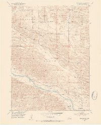
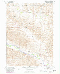
The Middle Loup River winds through the southern portion of this Nebraska landscape, defining the hydrological character of the region. This 1952 survey, part of the Missouri River Basin development program, captures a time when irrigation efforts were undergoing significant change. This is evidenced by the presence of the Rankin Ditch (Abandoned) alongside the active Rankin Ditch, showing the evolution of water management in the plains. Along the river banks, a Gaging Station monitors flow near the mouth of Rifle Creek. The map documents a sparsely populated ranching economy within the boundaries of Brewster and Edith. Prominent livestock operations include the Fowler Ranch to the north and the Hazen Ranch and McMillen Ranch further south. Local education is represented by the isolated School No 61, a key waypoint for genealogists tracing families in this corner of Blaine County.
Find a feature on this map
11 named features on this map. Tap any name to fly to it.
Don’t see what you’re looking for? This feature index may not catch every label — zoom into the map to look around manually.
Map Details
Editions of this 1952 Brewster SE Map
3 editions found
Other maps of this area

1951 · Anselmo NE
USGS Topo · 1:24,000

1951 · Anselmo NW
USGS Topo · 1:24,000

1951 · Milburn
USGS Topo · 1:24,000

1952 · Brewster
USGS Topo · 1:24,000

1952 · Almeria NW
USGS Topo · 1:24,000

1952 · Almeria SW
USGS Topo · 1:24,000

1952 · Brewster SW
USGS Topo · 1:24,000

1952 · Brewster NW
USGS Topo · 1:24,000

1955 · Broken Bow
USGS Topo · 1:250,000

1956 · Broken Bow
USGS Topo · 1:250,000