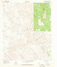
1962 Map of Antelope Creek SE
USGS Topo · Published 1966About this map
Swenson Field occupies the lower half of this landscape, characterized by the intricate drainage systems of Throckmorton County during the early 1960s. The terrain is defined by a dense network of seasonal and permanent watercourses, including Antelope Creek, Wolf Creek, and Sulphur Creek, which carve through the open country. The presence of several Oil Well sites and a prominent Pipeline indicate the importance of the local petroleum industry in this era, while a dedicated Landing Strip suggests the necessity of aerial access to this rural Texas environment.
Find a feature on this map
16 named features on this map. Tap any name to fly to it.
Don’t see what you’re looking for? This feature index may not catch every label — zoom into the map to look around manually.
Map Details
Editions of this 1962 Antelope Creek SE Map
3 editions found
Other maps of this area

1954 · Wichita Falls
USGS Topo · 1:250,000

1958 · Wichita Falls
USGS Topo · 1:250,000

1962 · Antelope Creek SW
USGS Topo · 1:24,000

1962 · Antelope Creek SE
USGS Topo · 1:24,000

1962 · Antelope Creek NE
USGS Topo · 1:24,000

1962 · Antelope Creek NW
USGS Topo · 1:24,000

1965 · Reynolds Bend NW
USGS Topo · 1:24,000

1966 · Rock Canyon
USGS Topo · 1:24,000

1966 · Westover SW
USGS Topo · 1:24,000

1966 · Tonk Creek
USGS Topo · 1:24,000