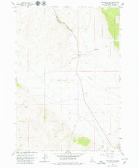
1963 Map of Antelope Flat
USGS Topo · Published 1979About this map
Antelope Flat defines the central basin of this Custer County landscape, situated between high ridges and the winding drainage of Warm Spring Creek. Surveyed in the early 1960s, the map reveals a remote environment primarily characterized by its water sources and rugged transit corridors. Grand View Canyon cuts through the northern section, while a series of mountain streams including McGowan Creek, Gooseberry Creek, and Sheep Creek flow toward the valley floor. The eastern boundary is marked by the Challis National Forest line, indicating a transition from open flatlands to protected timberland. Human activity is sparse but evident through a network of Jeep Trails and a local Gravel Pit, reflecting the area's use for ranching, resource extraction, and high-desert navigation. The map also records several specific water points like Summit Spring, which were critical for travel and livestock in this arid high-elevation terrain.
Find a feature on this map
14 named features on this map. Tap any name to fly to it.
Don’t see what you’re looking for? This feature index may not catch every label — zoom into the map to look around manually.
Map Details
Editions of this 1963 Antelope Flat Map
2 editions found
Other maps of this area

1929 · Bayhorse
USGS Topo · 1:125,000

1935 · Borah Peak
USGS Topo · 1:125,000

1938 · Borah Peak
USGS Topo · 1:125,000

1955 · Dubois
USGS Topo · 1:250,000

1956 · Doublespring
USGS Topo · 1:62,500

1957 · Challis
USGS Topo · 1:250,000

1958 · Dubois
USGS Topo · 1:250,000

1960 · Challis
USGS Topo · 1:250,000

1963 · Challis
USGS Topo · 1:250,000
1963 · Little Antelope Flat
USGS Topo · 1:24,000