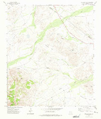
1972 Map of Antelope Flat
USGS Topo · Published 1975About this map
Kaiser Peak and Mount Annie anchor the high ground in the southwestern corner of this survey, looking out over a landscape defined by the drainage basins of the Trans-Pecos. The terrain transitions from these heights into the broad expanses of Antelope Flat and Augustine Flat, where the water economy of the early 1970s is visible through scattered infrastructure. Named water sources such as Joe Kingston Well, Clark Well, and the Pole Pen Windmill indicate the vital ranching interests of the era.
Find a feature on this map
24 named features on this map. Tap any name to fly to it.
Don’t see what you’re looking for? This feature index may not catch every label — zoom into the map to look around manually.
Map Details
Editions of this 1972 Antelope Flat Map
This is the sole edition of this map. No revisions or reprints were ever made.
Other maps of this area

1894 · Valentine
USGS Topo · 1:125,000

1894 · Fort Davis
USGS Topo · 1:125,000

1897 · Valentine
USGS Topo · 1:125,000

1897 · Fort Davis
USGS Topo · 1:125,000

1921 · Toyah
USGS Topo · 1:125,000

1928 · Kent
USGS Topo · 1:125,000

1943 · Valentine
USGS Topo · 1:125,000

1954 · Van Horn
USGS Topo · 1:250,000

1954 · Pecos
USGS Topo · 1:250,000

1954 · Fort Stockton
USGS Topo · 1:250,000