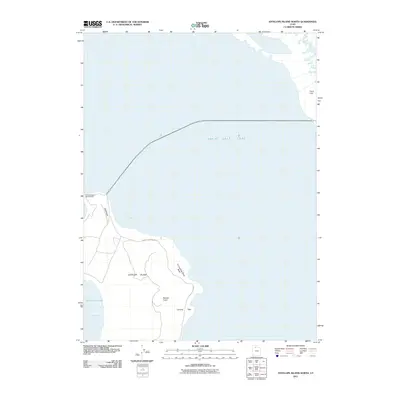
2011 Map of Antelope Island North
USGS Topo · Published 2011About this map
Antelope Island rises from the brine of the Great Salt Lake, serving as a focal point for recreation and conservation in the early 21st century. The northern tip of the island is marked by the Antelope Island Campground and the rocky peninsula of Ladyfinger, overlooking the waters of Buffalo Bay. A single main thoroughfare, Antelope Island Rd, provides access across the shoreline, connecting visitors to interior landmarks like the Tin Lambing Basin and the elevation at Beacon Knob. This survey captures the island's dual nature as both a natural refuge and a managed public space, where sheep-ranching history is hinted at by the names of basins and sheds. To the east, across the water, Payne Field sits near the mainland shoreline, highlighting the proximity between the remote island landscape and the developing communities of Davis County. The map details the precise interface of land and water at White Rock Bay and Camera Flats during this specific environmental era.
Find a feature on this map
13 named features on this map. Tap any name to fly to it.
Don’t see what you’re looking for? This feature index may not catch every label — zoom into the map to look around manually.
Map Details
Editions of this 2011 Antelope Island North Map
This is the sole edition of this map. No revisions or reprints were ever made.
Other maps of this area

1885 · Tooele Valley
USGS Topo · 1:250,000

1952 · Saltair NE
USGS Topo · 1:24,000

1953 · Tooele
USGS Topo · 1:250,000

1954 · Antelope Island
USGS Topo · 1:24,000

1954 · Antelope Island North
USGS Topo · 1:24,000

1954 · Brigham City
USGS Topo · 1:250,000

1955 · Clearfield
USGS Topo · 1:24,000

1955 · Roy
USGS Topo · 1:24,000

1955 · Ogden Bay
USGS Topo · 1:24,000

1955 · Fremont Island
USGS Topo · 1:24,000