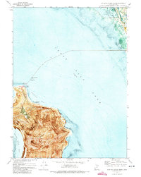
1972 Map of Antelope Island North
USGS Topo · Published 1973About this map
Antelope Island anchors the southern portion of this orthophotomap, showing the north end of the island as it appeared in the early 1970s. The topography is marked by notable features such as Ladyfinger Springs and the uniquely named Tin Lambing Shed Basin, while the island's eastern shore includes Camera Flats. This period of the Great Salt Lake is recorded with specific bathymetric soundings and contours, noting an elevation of 4200 feet in 1953. Along the northeastern shoreline, the Howard Slough Waterfowl Management Area meets the edge of the lake, providing a clear view of the interface between the marshlands and the open water of the Howard Slough. Infrastructure for lake access and monitoring is present via a Boat Ramp near Ladyfinger and a Gaging Station 4203 on the northern coast.
Find a feature on this map
21 named features on this map. Tap any name to fly to it.
Don’t see what you’re looking for? This feature index may not catch every label — zoom into the map to look around manually.
Map Details
Editions of this 1972 Antelope Island North Map
This is the sole edition of this map. No revisions or reprints were ever made.
Other maps of this area

1885 · Tooele Valley
USGS Topo · 1:250,000

1952 · Saltair NE
USGS Topo · 1:24,000

1953 · Tooele
USGS Topo · 1:250,000

1954 · Antelope Island
USGS Topo · 1:24,000

1954 · Antelope Island North
USGS Topo · 1:24,000

1954 · Brigham City
USGS Topo · 1:250,000

1955 · Clearfield
USGS Topo · 1:24,000

1955 · Roy
USGS Topo · 1:24,000

1955 · Ogden Bay
USGS Topo · 1:24,000

1955 · Fremont Island
USGS Topo · 1:24,000