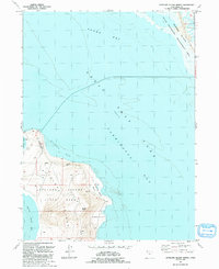
1991 Map of Antelope Island North
USGS Topo · Published 1991About this map
Antelope Island rises from the southeastern reaches of the Great Salt Lake in this 1991 revision, a landscape defined by dramatic shifts in shoreline and protected wildlife habitats. The northern peninsula of the island is home to Antelope Island State Park, where landmarks like Beacon Knob and the Tin Lambing Shed Basin overlook the surrounding waters. To the east, Farmington Bay and Howard Slough highlight the complex hydrological environment managed within the State Waterfowl Management Area.
Find a feature on this map
17 named features on this map. Tap any name to fly to it.
Don’t see what you’re looking for? This feature index may not catch every label — zoom into the map to look around manually.
Map Details
Editions of this 1991 Antelope Island North Map
This is the sole edition of this map. No revisions or reprints were ever made.
Other maps of this area

1885 · Tooele Valley
USGS Topo · 1:250,000

1952 · Saltair NE
USGS Topo · 1:24,000

1953 · Tooele
USGS Topo · 1:250,000

1954 · Antelope Island
USGS Topo · 1:24,000

1954 · Antelope Island North
USGS Topo · 1:24,000

1954 · Brigham City
USGS Topo · 1:250,000

1955 · Clearfield
USGS Topo · 1:24,000

1955 · Roy
USGS Topo · 1:24,000

1955 · Ogden Bay
USGS Topo · 1:24,000

1955 · Fremont Island
USGS Topo · 1:24,000