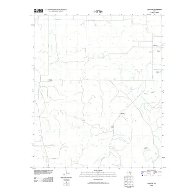
2010 Map of Antelope
USGS Topo · Published 2010About this map
Antelope serves as a central hub in this Jack County landscape, where the rural road network converges near the Antelope Cemetery. The terrain is defined by the headwaters and tributaries of the West Fork Trinity River, which winds through the southern portion of the quadrangle. North of the river, the Hoefle Oil Field indicates the region's industrial ties to petroleum extraction, a common feature of this North Texas geography. Prominent landforms such as Backbone Mountain and Mount Lebo provide significant elevation changes relative to the surrounding creek valleys. Smaller settlements like Shannon and Oakland are positioned along local routes like FM 175 and Oakland Rd, maintaining the area's historical settlement pattern. Water resources are marked by several man-made and natural features, including Ellenburg Lake, held by the Ellenburg Lake Dam, and the smaller Smith Lake further south.
Find a feature on this map
35 named features on this map. Tap any name to fly to it.
Don’t see what you’re looking for? This feature index may not catch every label — zoom into the map to look around manually.
Map Details
Editions of this 2010 Antelope Map
This is the sole edition of this map. No revisions or reprints were ever made.
Other maps of this area

1954 · Wichita Falls
USGS Topo · 1:250,000

1958 · Wichita Falls
USGS Topo · 1:250,000

1962 · Windthorst
USGS Topo · 1:24,000

1962 · Antelope Creek NE
USGS Topo · 1:24,000

1964 · Johnson Lake
USGS Topo · 1:24,000

1964 · Darnell Branch
USGS Topo · 1:24,000

1964 · Lynn Creek
USGS Topo · 1:24,000

1964 · Antelope
USGS Topo · 1:24,000

1964 · Scotland SE
USGS Topo · 1:24,000
1964 · Postoak
USGS Topo · 1:24,000