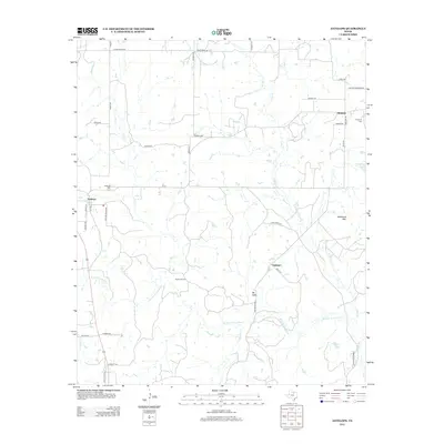
2012 Map of Antelope
USGS Topo · Published 2012About this map
Antelope and the small settlements of Shannon and Oakland anchor this rural landscape in Jack County, where the W Fork Trinity River and its many tributaries, including Flat Cr and Lodge Cr, shape the terrain. The presence of the Hoefle Oil Field and numerous local roads named after early families—such as Barry Rd, Watson Rd, and Raht Rd—reflects a long history of local industry and homesteading. Notable landmarks like Backbone Mtn and Mt Lebo rise above the drainage basins, while the Antelope Cem and Shannon Cem serve as vital markers for genealogical research. The map captures a late 20th-century transition, showing modern Farm-to-Market roads like FM-175 alongside older local routes such as China Ridge Rd and School House Rd, illustrating the evolution of transport in north-central Texas.
Find a feature on this map
44 named features on this map. Tap any name to fly to it.
Don’t see what you’re looking for? This feature index may not catch every label — zoom into the map to look around manually.
Map Details
Editions of this 2012 Antelope Map
This is the sole edition of this map. No revisions or reprints were ever made.
Other maps of this area

1954 · Wichita Falls
USGS Topo · 1:250,000

1958 · Wichita Falls
USGS Topo · 1:250,000

1962 · Windthorst
USGS Topo · 1:24,000

1962 · Antelope Creek NE
USGS Topo · 1:24,000

1964 · Johnson Lake
USGS Topo · 1:24,000

1964 · Darnell Branch
USGS Topo · 1:24,000

1964 · Lynn Creek
USGS Topo · 1:24,000

1964 · Antelope
USGS Topo · 1:24,000

1964 · Scotland SE
USGS Topo · 1:24,000
1964 · Postoak
USGS Topo · 1:24,000