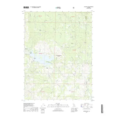
2018 Map of Antelope Lake
USGS Topo · Published 2018About this map
Antelope Lake serves as the central focal point for this section of the Plumas National Forest, where the topography is defined by complex drainage systems and ridges. The lake itself features distinctive landmarks such as Dedication Island and Long Point, while the surrounding basin is fed by Indian Cr, Lost Cr, and Little Antelope Cr. The map reveals a dense network of forest service roads and tracks, including the Janesville Grade and various specialized routes like the Wemple Cabin and Frazier Cabin paths. These names, along with landmarks like Doctor Smith Flat and Hallett Meadow, suggest a landscape historically shaped by early grazing, timber management, and remote mountain homesteading. High points like Clarks Peak and Wildcat Ridge overlook a terrain interspersed with seasonal springs like Chipmunk Spring and high-elevation openings such as Dry Flat.
Find a feature on this map
60 named features on this map. Tap any name to fly to it.
Don’t see what you’re looking for? This feature index may not catch every label — zoom into the map to look around manually.
Map Details
Editions of this 2018 Antelope Lake Map
This is the sole edition of this map. No revisions or reprints were ever made.
Other maps of this area

1886 · Honey Lake
USGS Topo · 1:250,000

1891 · Honey Lake
USGS Topo · 1:250,000

1893 · Honey Lake
USGS Topo · 1:250,000

1950 · Kettle Rock
USGS Topo · 1:62,500

1950 · Milford
USGS Topo · 1:62,500

1954 · Susanville
USGS Topo · 1:62,500

1954 · Litchfield
USGS Topo · 1:62,500

1955 · Westwood
USGS Topo · 1:250,000

1958 · Westwood
USGS Topo · 1:250,000

1959 · Westwood
USGS Topo · 1:250,000