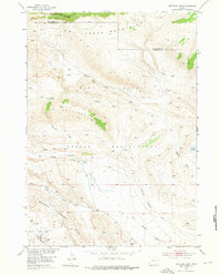
1952 Map of Antelope Ridge
USGS Topo · Published 1976About this map
The Wind River Indian Reservation covers the southern portion of this high-altitude landscape, where the Owl Creek Mountains form a massive northern barrier along the boundary of Hot Springs and Fremont counties. The terrain is defined by complex drainage systems and structural geological features, notably the Maverick Spring Dome in the southwest corner. Water management is central to the area's utility, evidenced by the presence of the Blue Draw Ditch and several livestock or irrigation water sources like Bargee Reservoir and Pearl Res. Erosion has carved distinct landforms such as Red Basin and Antelope Basin, which are bisected by seasonal watercourses like Antelope Springs Creek and Dry Muddy Creek. This survey captures the region just as petroleum exploration was becoming established, marked by an isolated Oil Well near the Maverick Spring oil field area.
Find a feature on this map
18 named features on this map. Tap any name to fly to it.
Don’t see what you’re looking for? This feature index may not catch every label — zoom into the map to look around manually.
Map Details
Editions of this 1952 Antelope Ridge Map
3 editions found
Other maps of this area

1904 · Kirwin
USGS Topo · 1:125,000

1906 · Kirwin
USGS Topo · 1:125,000

1951 · Eagle Point
USGS Topo · 1:24,000

1951 · Maverick Spring
USGS Topo · 1:24,000

1952 · Antelope Ridge
USGS Topo · 1:24,000

1952 · Crowheart NE
USGS Topo · 1:24,000

1952 · Bargee
USGS Topo · 1:24,000

1955 · Thermopolis
USGS Topo · 1:250,000

1957 · Crowheart NE
USGS Topo · 1:24,000

1958 · Thermopolis
USGS Topo · 1:250,000