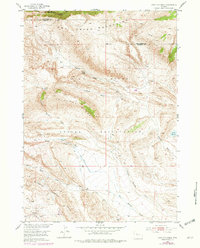
1952 Map of Antelope Ridge
USGS Topo · Published 1979About this map
The Wind River Indian Reservation occupies the southern portion of this mid-century landscape, where the rugged terrain of the Owl Creek Mountains meets the industrial footprint of the Maverick Spring Oil Field. This 1952 survey, updated with late-1970s revisions, illustrates the resource extraction economy of the era, marked by numerous Oil Wells and the distinct geological structure of the Maverick Spring Dome. Hydrology in this arid region is defined by ephemeral drainages and essential water sources like South Fork Owl Creek and Bargee Reservoir. The map provides a clear look at the Antelope Ridge and Antelope Basin areas, tracing the paths of Dry Muddy Creek and Sagwup Draw through the complex topography along the Hot Springs and Fremont county line.
Find a feature on this map
17 named features on this map. Tap any name to fly to it.
Don’t see what you’re looking for? This feature index may not catch every label — zoom into the map to look around manually.
Map Details
Editions of this 1952 Antelope Ridge Map
3 editions found
Other maps of this area

1904 · Kirwin
USGS Topo · 1:125,000

1906 · Kirwin
USGS Topo · 1:125,000

1951 · Eagle Point
USGS Topo · 1:24,000

1951 · Maverick Spring
USGS Topo · 1:24,000

1952 · Antelope Ridge
USGS Topo · 1:24,000

1952 · Crowheart NE
USGS Topo · 1:24,000

1952 · Bargee
USGS Topo · 1:24,000

1955 · Thermopolis
USGS Topo · 1:250,000

1957 · Crowheart NE
USGS Topo · 1:24,000

1958 · Thermopolis
USGS Topo · 1:250,000