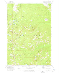
1972 Map of Anthony Lakes
USGS Topo · Published 1976About this map
Whitman National Forest contains a complex system of alpine basins and granite peaks where the boundaries of Union, Baker, and Grant counties converge. High-altitude water bodies like Anthony Lake, Grande Ronde Lake, and Lilypad Lake are clustered in the northwest, supported by infrastructure including several campgrounds and a Picnic Area. The landscape is defined by its glacial heritage, featuring dramatic landforms such as Gunsight Mountain, Angell Basin, and Cunningham Cove.
Find a feature on this map
62 named features on this map. Tap any name to fly to it.
Don’t see what you’re looking for? This feature index may not catch every label — zoom into the map to look around manually.
Map Details
Editions of this 1972 Anthony Lakes Map
2 editions found
Other maps of this area

1901 · Sumpter
USGS Topo · 1:125,000

1953 · Pendleton
USGS Topo · 1:250,000

1955 · Canyon City
USGS Topo · 1:250,000

1956 · Pendleton
USGS Topo · 1:250,000

1959 · Canyon City
USGS Topo · 1:250,000

1965 · Limber Jim Creek
USGS Topo · 1:24,000

1965 · Anthony Butte
USGS Topo · 1:24,000
1965 · Tucker Flat
USGS Topo · 1:24,000
1972 · Elkhorn Peak
USGS Topo · 1:24,000

1972 · Mt. Ireland
USGS Topo · 1:24,000