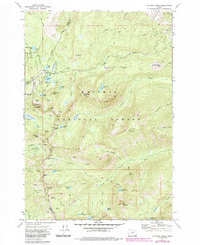
1972 Map of Anthony Lakes
USGS Topo · Published 1985About this map
Whitman National Forest dominates this 1970s landscape, centered on the high-elevation glacial basins of the Elkhorn Mountains. The map reveals a cluster of recreational and resource-driven activity near the county lines of Baker, Union, and Grant. Substantial water bodies like Anthony Lake, Grande Ronde Lake, and Killamacue Lake are connected by a network of Pack Trails and Jeep Tracks, suggesting a transition toward mountain recreation while maintaining ties to its extractive past.
Find a feature on this map
69 named features on this map. Tap any name to fly to it.
Don’t see what you’re looking for? This feature index may not catch every label — zoom into the map to look around manually.
Map Details
Editions of this 1972 Anthony Lakes Map
2 editions found
Other maps of this area

1901 · Sumpter
USGS Topo · 1:125,000

1953 · Pendleton
USGS Topo · 1:250,000

1955 · Canyon City
USGS Topo · 1:250,000

1956 · Pendleton
USGS Topo · 1:250,000

1959 · Canyon City
USGS Topo · 1:250,000

1965 · Limber Jim Creek
USGS Topo · 1:24,000

1965 · Anthony Butte
USGS Topo · 1:24,000
1965 · Tucker Flat
USGS Topo · 1:24,000
1972 · Elkhorn Peak
USGS Topo · 1:24,000

1972 · Mt. Ireland
USGS Topo · 1:24,000