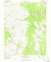
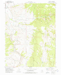
1970 Map of Antimony
USGS Topo · Published 1972About this map
Antimony sits at the northern edge of this high-plateau landscape, where the Sevier River meets the drainages of Antimony Creek. The town is flanked by the broad expanse of Antimony Bench and the rising slopes of the Dixie National Forest. This 1970 field-checked survey highlights the area's agricultural and industrial history, marking the Antimony Cem and a Mill (Ruins) located further up the canyon near a gaging station.
Find a feature on this map
36 named features on this map. Tap any name to fly to it.
Don’t see what you’re looking for? This feature index may not catch every label — zoom into the map to look around manually.
Map Details
Editions of this 1970 Antimony Map
2 editions found
Other maps of this area

1885 · Beaver
USGS Topo · 1:250,000

1885 · Fish Lake
USGS Topo · 1:250,000

1886 · Kanab
USGS Topo · 1:250,000

1886 · Escalante
USGS Topo · 1:250,000

1896 · Fish Lake
USGS Topo · 1:250,000

1953 · Richfield
USGS Topo · 1:250,000

1953 · Cedar City
USGS Topo · 1:250,000

1956 · Escalante
USGS Topo · 1:250,000

1956 · Salina
USGS Topo · 1:250,000

1958 · Richfield
USGS Topo · 1:250,000