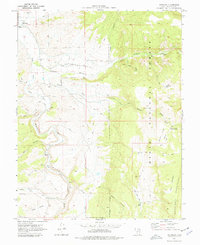
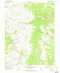
1970 Map of Antimony
USGS Topo · Published 1977About this map
The town of Antimony and the high plateaus of the Dixie National Forest define this rugged corridor along the East Fork Sevier River. Mapped in 1970, the area shows a clear distinction between the agricultural valley floor and the industrial history of the uplands. The presence of the Mill (Ruins) on Antimony Creek and the Antimony Cem on the Antimony Bench point to the area's early mining and milling heritage. Moving south into Black Canyon, the settlement of Osiris appears tucked against the river, while the higher elevations are marked by a network of Jeep Trails and Pack Trails leading to water features like Antimony Lake and Poison Creek Reservoir No 2. This survey documents the transition from early resource extraction to the recreational and land management patterns of the late twentieth century.
Find a feature on this map
38 named features on this map. Tap any name to fly to it.
Don’t see what you’re looking for? This feature index may not catch every label — zoom into the map to look around manually.
Map Details
Editions of this 1970 Antimony Map
2 editions found
Other maps of this area

1885 · Beaver
USGS Topo · 1:250,000

1885 · Fish Lake
USGS Topo · 1:250,000

1886 · Kanab
USGS Topo · 1:250,000

1886 · Escalante
USGS Topo · 1:250,000

1896 · Fish Lake
USGS Topo · 1:250,000

1953 · Richfield
USGS Topo · 1:250,000

1953 · Cedar City
USGS Topo · 1:250,000

1956 · Escalante
USGS Topo · 1:250,000

1956 · Salina
USGS Topo · 1:250,000

1958 · Richfield
USGS Topo · 1:250,000