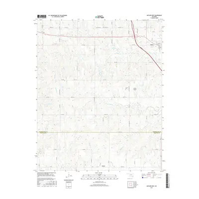
2016 Map of Antlers West
USGS Topo · Published 2016About this map
Antlers sits in the northeastern corner of this 2016 survey, a hub for the surrounding landscape of eastern Oklahoma. The terrain is defined by a dense network of watercourses, including the wide drainage of Dumpling Cr and the marshy area known as Lamey Slash. To the south, the settlement of Nelson serves as a secondary landmark near the small reservoir of Krebs Lake. The map details a transition across the Pushmataha County and Choctaw County line, documenting the rural road system that connects scattered homesites and agricultural tracts. Notable local sites include Antlers City Cem and Edwards Cem, which provide valuable points of reference for genealogists. The presence of the Antlers Municipal Airport and several prominent creek systems like Bokchito Cr and Beaver Cr illustrate the modern layout of this timber and cattle-rich region.
Find a feature on this map
59 named features on this map. Tap any name to fly to it.
Don’t see what you’re looking for? This feature index may not catch every label — zoom into the map to look around manually.
Map Details
Editions of this 2016 Antlers West Map
This is the sole edition of this map. No revisions or reprints were ever made.
Other maps of this area

1901 · Antlers
USGS Topo · 1:125,000

1912 · Antlers
USGS Topo · 1:125,000

1925 · Antlers
USGS Topo · 1:125,000

1950 · Mcalester
USGS Topo · 1:250,000

1957 · Farris
USGS Topo · 1:24,000

1957 · Moyers
USGS Topo · 1:24,000
1961 · Darwin
USGS Topo · 1:24,000

1961 · Antlers East
USGS Topo · 1:24,000

1961 · Antlers West
USGS Topo · 1:24,000

1962 · McAlester
USGS Topo · 1:250,000