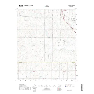
2019 Map of Antlers West
USGS Topo · Published 2019About this map
The town of Antlers serves as the focal point for this survey of southeastern Oklahoma, situated where the Indian Nation Tpke intersects with established routes like W Main St. The landscape transitions from the urbanized grid of the town, featuring the Antlers City Cem, to a rugged interior defined by a network of creeks. Significant watercourses such as Beaver Cr, Coffee Cr, and the slow-moving Caney Slash carve through the terrain, illustrating the hydrological patterns of the Kiamichi River valley region. To the south, the settlement of Nelson and the waters of Krebs Lake mark the transition across the Pushmataha Co Choctaw Co boundary. The map captures a mix of rural development and municipal infrastructure, including the Antlers Municipal Airport and isolated family-named landmarks like Edwards Cem, reflecting the area's agricultural and transit-based economy.
Find a feature on this map
70 named features on this map. Tap any name to fly to it.
Don’t see what you’re looking for? This feature index may not catch every label — zoom into the map to look around manually.
Map Details
Editions of this 2019 Antlers West Map
This is the sole edition of this map. No revisions or reprints were ever made.
Other maps of this area

1901 · Antlers
USGS Topo · 1:125,000

1912 · Antlers
USGS Topo · 1:125,000

1925 · Antlers
USGS Topo · 1:125,000

1950 · Mcalester
USGS Topo · 1:250,000

1957 · Farris
USGS Topo · 1:24,000

1957 · Moyers
USGS Topo · 1:24,000
1961 · Darwin
USGS Topo · 1:24,000

1961 · Antlers East
USGS Topo · 1:24,000

1961 · Antlers West
USGS Topo · 1:24,000

1962 · McAlester
USGS Topo · 1:250,000