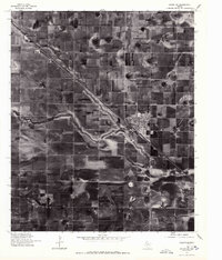
1976 Map of Anton SW
USGS Topo · Published 1978About this map
The High Plains of West Texas are captured in this 1976 orthophotograph, showcasing the vast agricultural grid of Hockley County. The town of Anton sits as the primary hub of the region, positioned along a major diagonal transportation corridor that cuts through the rectilinear cotton fields and playa lake depressions common to this landscape. Further northwest along the same rail and road alignment lies Bainer, a smaller point on the map that reflects the region's reliance on efficient transit for moving agricultural products. This map provides a distinct photographic perspective on the land use and irrigation patterns of the mid-1970s, revealing the precise geometry of rural life and the natural drainage features that break the otherwise uniform Texas plains.
Find a feature on this map
2 named features on this map. Tap any name to fly to it.
Don’t see what you’re looking for? This feature index may not catch every label — zoom into the map to look around manually.
Map Details
Editions of this 1976 Anton SW Map
This is the sole edition of this map. No revisions or reprints were ever made.
Other maps of this area

1954 · Brownfield
USGS Topo · 1:250,000

1957 · Anton
USGS Topo · 1:62,500

1957 · Wolfforth
USGS Topo · 1:62,500

1958 · Brownfield
USGS Topo · 1:250,000

1962 · Brownfield
USGS Topo · 1:250,000

1964 · Littlefield
USGS Topo · 1:24,000

1964 · Lums Chapel
USGS Topo · 1:24,000

1964 · Whitharral
USGS Topo · 1:24,000
1976 · Wolfforth NW
USGS Topo · 1:24,000
1976 · Wolfforth NE
USGS Topo · 1:24,000