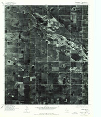
1976 Map of Wolfforth NE
USGS Topo · Published 1978About this map
Agricultural patterns dominate this orthophotoquad of the High Plains near Lubbock in the mid-1970s. The most prominent natural feature is the winding course of Yellow House Draw, which cuts across the upper half of the landscape. This drainage channel, historically significant as a water source in the semi-arid Llano Estacado, is captured here as it appeared in March 1976. The surrounding terrain is an intensive grid of center-pivot irrigation circles and rectangular fields, illustrating the scale of West Texas cotton and grain production during this era. The aerial photography highlights the intersection of natural topography and human engineering, showing how the draw's meandering path interacts with the rigid boundaries of the local road and section network.
Find a feature on this map
1 named feature on this map. Tap any name to fly to it.
Don’t see what you’re looking for? This feature index may not catch every label — zoom into the map to look around manually.
Map Details
Editions of this 1976 Wolfforth NE Map
This is the sole edition of this map. No revisions or reprints were ever made.
Other maps of this area

1954 · Lubbock
USGS Topo · 1:250,000

1954 · Brownfield
USGS Topo · 1:250,000

1956 · Shallowater
USGS Topo · 1:24,000

1957 · Lubbock West
USGS Topo · 1:24,000

1957 · Lubbock
USGS Topo · 1:62,500

1957 · Anton
USGS Topo · 1:62,500

1957 · Abernathy
USGS Topo · 1:62,500

1957 · Wolfforth
USGS Topo · 1:62,500

1958 · Brownfield
USGS Topo · 1:250,000

1962 · Brownfield
USGS Topo · 1:250,000