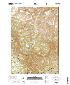
2020 Map of Antone
USGS Topo · Published 2020About this map
Ochoco National Forest dominates the southern landscape of this Wheeler County terrain, where high-elevation landmarks like Spanish Peak and Ochoco Mountain define the horizon. The northern portion of the map reveals a history of land management and isolated homesteading, marked by the presence of the Antone Ranch Airport and the lonely Mary Waterman Grave near Rock Creek. Water management is a central theme of this arid region, evidenced by the intricate Rock Cr-Philling-McFadden Ditch and the Erickson Ditch which siphon flows across the valley floors. Several named springs, including Ted Glover Spring and Edmonson Spring, appear as critical water sources in a landscape characterized by deep drainages like Spanish Gulch and Mule Gulch. The Spanish Gulch Cemetery remains as a quiet indicator of the small communities that once attempted to find a foothold in these high valleys.
Find a feature on this map
94 named features on this map. Tap any name to fly to it.
Don’t see what you’re looking for? This feature index may not catch every label — zoom into the map to look around manually.
Map Details
Editions of this 2020 Antone Map
This is the sole edition of this map. No revisions or reprints were ever made.
Other maps of this area

1932 · Dayville
USGS Topo · 1:125,000

1936 · Dayville
USGS Topo · 1:125,000

1953 · Richmond
USGS Topo · 1:62,500

1953 · Picture
USGS Topo · 1:62,500

1955 · Canyon City
USGS Topo · 1:250,000

1959 · Canyon City
USGS Topo · 1:250,000

1966 · Antone
USGS Topo · 1:24,000
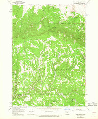
1966 · Derr Meadows
USGS Topo · 1:24,000

1966 · Little Summit Prairie
USGS Topo · 1:24,000

1966 · Six Corners
USGS Topo · 1:24,000