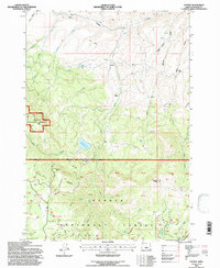
1992 Map of Antone
USGS Topo · Published 1997About this map
Antone serves as the focal point of this Wheeler County landscape, situated where the terrain transitions into the high country of the Ochoco National Forest. The mapping reveals a history of resource extraction and ranching, evidenced by the presence of the Waterman Mine and Andrews Mine in the northeastern section, alongside more isolated features like the Erickson Ranch and Mascall Corrals. A small Cem (cemetery) located near Mule Gulch provides a quiet connection to the early families who settled this drainage system.
Find a feature on this map
58 named features on this map. Tap any name to fly to it.
Don’t see what you’re looking for? This feature index may not catch every label — zoom into the map to look around manually.
Map Details
Editions of this 1992 Antone Map
This is the sole edition of this map. No revisions or reprints were ever made.
Other maps of this area

1932 · Dayville
USGS Topo · 1:125,000

1936 · Dayville
USGS Topo · 1:125,000

1953 · Richmond
USGS Topo · 1:62,500

1953 · Picture
USGS Topo · 1:62,500

1955 · Canyon City
USGS Topo · 1:250,000

1959 · Canyon City
USGS Topo · 1:250,000

1966 · Antone
USGS Topo · 1:24,000
1966 · Derr Meadows
USGS Topo · 1:24,000

1966 · Little Summit Prairie
USGS Topo · 1:24,000

1966 · Six Corners
USGS Topo · 1:24,000