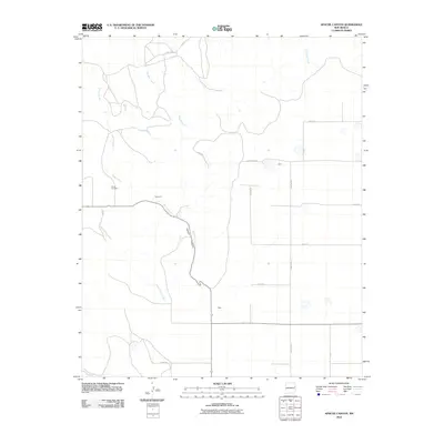
2010 Map of Apache Canyon
USGS Topo · Published 2010About this map
Apache Canyon and the high plains of Quay County are defined by a network of ephemeral drainages and rural settlements in this 2010 topographic record. The landscape is carved by Apache Creek, Saladito Creek, and Dog Canyon Creek, revealing the natural erosion patterns of the eastern New Mexico terrain. Human presence is marked by the small communities of Brochard and Duke, situated amidst a grid of rural routes such as Quay Road V and Quay Road 48. Genealogists will find particular value in the location of Brown Cemetery, perched near the banks of Apache Creek. The map illustrates how local life and infrastructure, including the various designated Quay Rd corridors, have been adapted to the contours of the canyon and the winding paths of the region's seasonal waterways.
Find a feature on this map
17 named features on this map. Tap any name to fly to it.
Don’t see what you’re looking for? This feature index may not catch every label — zoom into the map to look around manually.
Map Details
Editions of this 2010 Apache Canyon Map
This is the sole edition of this map. No revisions or reprints were ever made.
Other maps of this area

1930 · Tucumcari
USGS Topo · 1:125,000

1954 · Tucumcari
USGS Topo · 1:250,000

1954 · Clovis
USGS Topo · 1:250,000

1958 · Clovis
USGS Topo · 1:250,000

1958 · Tucumcari
USGS Topo · 1:250,000

1968 · San Jon
USGS Topo · 1:24,000

1968 · Bedford Hill
USGS Topo · 1:24,000
1968 · Tucumcari SE
USGS Topo · 1:24,000
1971 · Apache Canyon
USGS Topo · 1:24,000

1971 · Wheatland
USGS Topo · 1:24,000