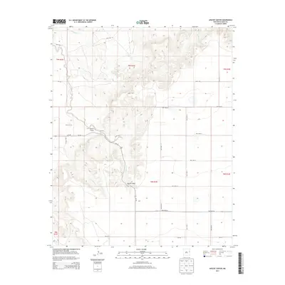
2013 Map of Apache Canyon
USGS Topo · Published 2013About this map
Apache Canyon carves a deep path through the High Plains of eastern New Mexico, defining the drainage patterns for numerous waterways like Apache Creek and Dog Canyon Cr. This 2013 survey reveals a landscape largely dominated by the Public Land Survey System grid, where local travel is dictated by numbered routes such as NM-278 and a network of arterial roads including Quay Road 44. Small settlements like Brochard and Duke serve as anchors in an otherwise open ranching or agricultural environment. Local history is physically represented by the Brown Cem, situated near the upper reaches of the canyon. The northern portion of the map is punctuated by several ephemeral streams, including Saladito Cr and San Jon Cr, which emphasize the arid character of the Quay County terrain.
Find a feature on this map
30 named features on this map. Tap any name to fly to it.
Don’t see what you’re looking for? This feature index may not catch every label — zoom into the map to look around manually.
Map Details
Editions of this 2013 Apache Canyon Map
This is the sole edition of this map. No revisions or reprints were ever made.
Other maps of this area

1930 · Tucumcari
USGS Topo · 1:125,000

1954 · Tucumcari
USGS Topo · 1:250,000

1954 · Clovis
USGS Topo · 1:250,000

1958 · Clovis
USGS Topo · 1:250,000

1958 · Tucumcari
USGS Topo · 1:250,000

1968 · San Jon
USGS Topo · 1:24,000

1968 · Bedford Hill
USGS Topo · 1:24,000
1968 · Tucumcari SE
USGS Topo · 1:24,000
1971 · Apache Canyon
USGS Topo · 1:24,000

1971 · Wheatland
USGS Topo · 1:24,000