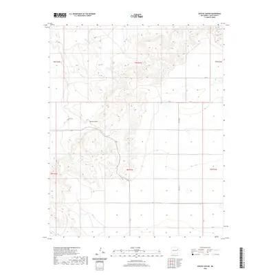
2020 Map of Apache Canyon
USGS Topo · Published 2020About this map
Apache Canyon forms a dramatic central geological corridor through this portion of Quay County, directing the flow of Apache Creek as it winds through the arid terrain. The landscape is defined by its drainage systems, including Saladito Cr and Dog Canyon Cr, which illustrate the complex watershed of the Llano Estacado's edge. A notable site for local researchers and genealogists is the Brown Cem, located near the northern entrance of the canyon. The map details a transition from the dissected canyon lands to the more level plains in the east, which are divided by a grid of rural routes such as Quay Road V and QR 49. This 2020 survey captures the persistence of traditional land divisions like t9n r33e, reflecting the enduring agricultural and ranching layout of eastern New Mexico.
Find a feature on this map
20 named features on this map. Tap any name to fly to it.
Don’t see what you’re looking for? This feature index may not catch every label — zoom into the map to look around manually.
Map Details
Editions of this 2020 Apache Canyon Map
This is the sole edition of this map. No revisions or reprints were ever made.
Other maps of this area

1930 · Tucumcari
USGS Topo · 1:125,000

1954 · Tucumcari
USGS Topo · 1:250,000

1954 · Clovis
USGS Topo · 1:250,000

1958 · Clovis
USGS Topo · 1:250,000

1958 · Tucumcari
USGS Topo · 1:250,000

1968 · San Jon
USGS Topo · 1:24,000

1968 · Bedford Hill
USGS Topo · 1:24,000
1968 · Tucumcari SE
USGS Topo · 1:24,000
1971 · Apache Canyon
USGS Topo · 1:24,000

1971 · Wheatland
USGS Topo · 1:24,000