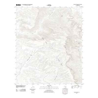
2011 Map of Apache Peak
USGS Topo · Published 2011About this map
Sierra Diablo dominates this West Texas landscape, defined by the sharp escarpment of the Diablo Rim and a network of deep drainages. This high-altitude desert terrain is etched by Apache Canyon to the north and several smaller watercourses like Mine Canyon and Marble Canyon that cut through the limestone cliffs. Human presence is sparse, centered on the Puett Ranch and the managed water resource at New Tank, which are essential nodes in this arid environment. The map details the primitive transportation network connecting these remote sites, including Garren Rd and Marvel Rd. Significant elevations like Apache Peak and Cave Peak provide clear landmarks for understanding the complex topography of the Trans-Pecos region during the early twenty-first century.
Find a feature on this map
14 named features on this map. Tap any name to fly to it.
Don’t see what you’re looking for? This feature index may not catch every label — zoom into the map to look around manually.
Map Details
Editions of this 2011 Apache Peak Map
This is the sole edition of this map. No revisions or reprints were ever made.
Other maps of this area

1895 · Sierra Blanca
USGS Topo · 1:125,000

1906 · Van Horn
USGS Topo · 1:125,000

1954 · Van Horn
USGS Topo · 1:250,000

1955 · Black Mountains
USGS Topo · 1:62,500

1958 · Van Horn
USGS Topo · 1:250,000

1973 · Bitter Well Mountain SW
USGS Topo · 1:24,000

1973 · Sneed Mountain NE
USGS Topo · 1:24,000
1973 · Victorio Peak
USGS Topo · 1:24,000

1973 · Apache Peak
USGS Topo · 1:24,000

1973 · Bitter Well Mountain
USGS Topo · 1:24,000